Everyday Life in a Northumbrian Manor
All Manor of Things: An introduction to manors and their documents
Other Documents
There are other types of manorial documents in our collections which were not included in the transcription project but are worth knowing about when doing research.
Rental
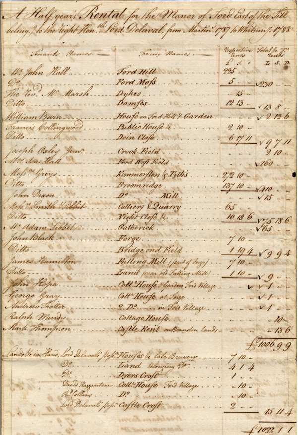
A rental is a survey of the lands in a manor and like a call roll, it often lists manorial tenants. It focuses more on the land which is being rented, and the money charged. Here is an example of a rental for Ford Manor:
Ford Rental: NRO 1216-B-2-1-3
Here, the lands east of the River Till in Ford manor are listed, with the tenant’s name and their half yearly rent. What makes these documents particularly interesting, is that they show what the various farms and other parts of the manor were worth in 1787/8.
Look at the top entry – John Hall is listed as the tenant for Ford Hill which has the second highest half yearly rental of £225. He is also the tenant of Ford Moss which has a rental of £5 and was later a colliery. There is a large difference in these rents, suggesting that Ford Hill is a much larger area of land and perhaps also, more lucrative.
The 12th entry is the Messers Grey, who rent Kimmerston and Tythes, suggesting that their rental included the tythe payments. Unsurpisingly, this rent is the highest at £272. 10 shillings, highlighting the value of that land.
Look through the rest of the document and see if you can find a public house, quarry, forge and fulling mill.
The Lord of the manor at this time was Lord Delaval. At the bottom of the document, his “demesne” lands have also been included in a separate section. These are the lands which he profited from solely. The grand total of rental income for Ford manor for that half year was £1022 1 s 1 d, in modern currency that would be £88,003.46 – not bad for half a year’s rental income!
Rentals can help us to understand the value of different buildings and businesses within a manor at a certain time and are an important source of information.
Surveys
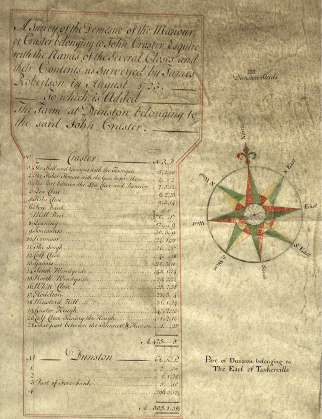
Like rentals, surveys tell us about land within a manor. These can include the value of the land but tend to focus more on the size of different parts. For example, here is a 1723 survey for Craster manor. The lord is John Craster, and the surveyor is James Robertson. Each plot of land is then listed individually and the size given in acres, roods and perches (A., R., P.). If no manorial maps survive, a survey can at least indicate the size of a manor. Here, the land in Craster manor totals 425 Acres and 5 perches, which is about 172 hectares or 1,720,042m2.
Craster Survey: ZCR/M/2
Perambulation
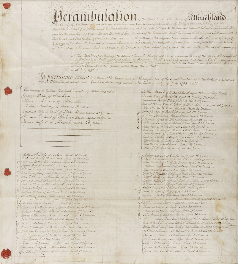
This is sometimes called a “perambulation of the bounds”. It is a written account of the boundaries of the manor, established by members of the court walking around the boundaries. These were sometimes completed in response to a boundary dispute but could also be done annually or at regular intervals. Here is an example for Blanchland manor:
Blanchland Perambulation – NRO 00452-E-3-3-1-2_001
This perambulation is dated 1793. The lord of the manor is the Trustees of the late Lord Crewe and all five are Reverends. Nathaniel, Lord Crewe was the Bishop of Durham which explains why his trustees are all members of the clergy. For more information please see our module on Lord Crewe and the work of Lord Crewe’s Charity.
Format of the Blanchland Perambulation
This is just the first page of a four-page document. It contains the following information which gives some insight into how it worked.
- Announcement – the initial paragraphs indicate that the perambulation was advertised in several newspapers, including the Newcastle Courant, and announced in several local churches. It informed tenants that it would take place on Wednesday 31 July, starting at 7am at Stony Burn Foot.
- Tenants who attended on the day are then listed – this includes their ages and so we know that the youngest tenant taking part was aged 13 and the oldest aged 72!
- The boundaries are then listed as they were seen during the ride around the manor, which was completed on horseback. The locations are named, and the distance between each given, e.g., “we travelled for three miles to Mr Smith’s land…we crossed a ford which was 3 yards wide”. This is a common way to describe the boundaries which makes it difficult to work them out today, even following the exact same path. For example, the ford may not still be there and where was Mr Smith’s land?
The document also tells us that clarinet players, violists and bagpipers accompanied the group – what a wonderful image! The perambulation lasted two days, ending at 1pm on Thursday 1 August, 1793 with “three loud huzzahs” and a ceremonial dropping of the flag.
If they survive, perambulations can tell us about the boundaries of a manor and also give us an insight into manorial traditions which will be different in each manor.
Maps
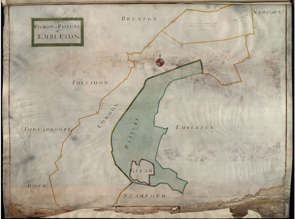
Manorial maps are rare although there are some in our collections. Here is a map for Embleton dated 1711:
Maps before the 17th century tend to look more like drawings – they may not be to scale and boundaries can be approximate. From the 18th Century onwards, they started to look a bit more like modern maps – more detailed, with proper boundaries and a scale. Manorial maps can survive but they are still a rare find in an archive.
Usually, manorial maps were drawn because of a dispute over boundary lines – for example, if a tenant felt someone had taken over their land. In these cases, the map only covers the land area involved in the dispute, not the entire manor.
Maps may also have been drawn up for the lord of a manor to help him identify the extent and value of his land, either as part of his accounts, or before selling land. They can provide details of how the land was divided up in a manor, indicating the size of each plot and the names of the tenants. If a map was created for the sale of a manor, it may also include the value of each tenanted plot.
Again, they can be a very useful source of information.
Other Records Available
Other manorial records which can be found include:
- Estreats – a copy of a court roll that only relates to manor fines.
- Terrier – a survey of land within a manor.
- Stewards’ papers – the administrative papers of the steward to the manor, including wills, correspondence and accounts.
- Extinguishments/Enfranchisements – the conversion of copyhold to freehold land.
Again, they are quite rare in our collections but would be listed in the Manorial Documents Register if they survive for a particular manor.

